Herodotus wrote in his Histories
56.
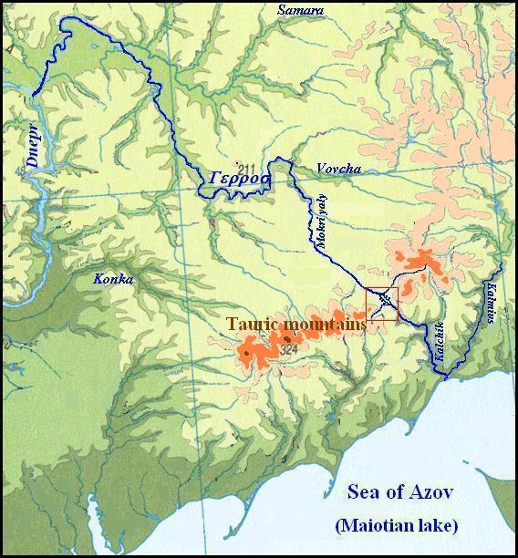
And first they (the slaves – V.S.) cut off their land by digging a broad trench extending from the Tauric mountains to the Maiotian lake, at the point where this is broadest. .
In such way, a water route has been created from the Dnieper to Sea of Azov, which Herodotus called Gerros:
56.
Seventh is the Gerros, which parts off from the Borysthenes near about that part of the country where the Borysthenes ceases to be known, - it parts off, I say, in this region and has the same name which this region itself has, namely Gerros; and as it flows to the sea it borders the country of the nomad and that of the Royal Scythians, and runs out into the Hypakyris.
|
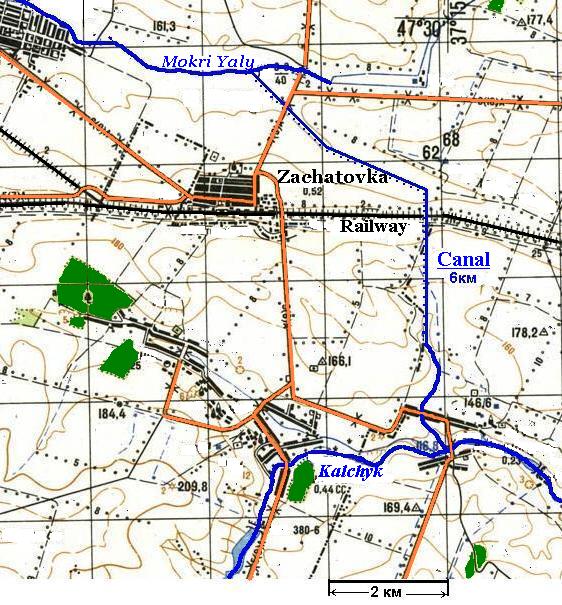
| Obviously, ancient inhabitants of the Azov Sea coast named by the Gerros the waterway has been formed by low currents of the Samara River, the rivers Vovcha, the Mokri Yaly, and the Kalchyk which runs in the Kalmius River near to its mouth. The Kalchik and the Mokri Yaly come so nearer to each other in one place that, else during rather near historical times, the Zaporozh Cossaks drew their boats from the one river in the another by land. This fact was described by G. de Bauplan though he has wrongly named the Kalchyk as the Miuss River (BAUPLAN de GUILLAME le VASSEUR, 1998). Closely considering a modern topographical map, one can see that the isthmus, which separates the Mokri Yaly from the small tributary of the Kalchyk, has the distance not more than six kilometres, and both rivers could be connected with a channel so that to form a continuous way from the Sea of Azov up to the Dnieper (See the map by left).
|
|
Left: The Gerros River - the Waterway from the Dnieper to Azov Sea.
|
|
The map shows that a narrow valley goes away from the Mokri Yaly River, it could be a small river in ancient times. Using this valley, it was possible to facilitate the work of hydraulic engineering, though increasing the length of the channel at the same time. Initially, this could just be a quagmire, which could be waded, and this explains the name of this whole waterway "Gerros" as a ford (the language of the Chuvash, distant descendants of the Scythians, has word kěre meaning "a ford"). |
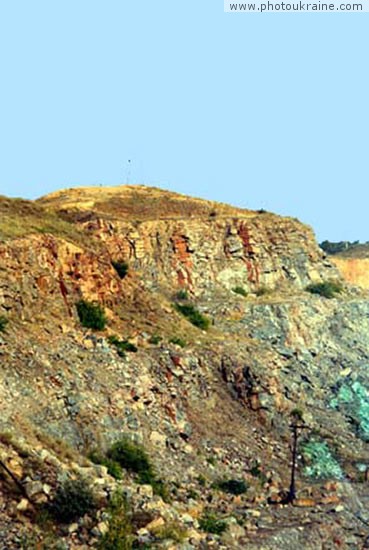
Right: Belmak-Mohyla, the highest top of Azov Elevation (324 m)
Herodotus wrote that slaves dug a broad trench extanding from Tauric Mountains. If the Tauric Mountains take as Azov Elevation, what is quite possible according to the appearance of Belmak-Mohyla, the trench would be this channel. Traces of the channel, in principle, can be found fairly easily, but now the isthmus railroad passes (see map below).
Closely considering a modern topographical map, one can see that the isthmus, which separates the Mokri Yaly from the small tributary of the Kalchyk, has the distance not more than six kilometers, and both rivers could be connected with a channel so that to form a continuous way from the Sea of Azov up to the Dnieper (see map below).
The map shows that a narrow valley leaves the Mokri Yaly River to south-east. It could be a small river in ancient times. Using this valley, it was possible to facilitate the work of hydraulic engineering, though increasing the length of the channel at the same time.
|
| Left: The canal connected the Mokri Yaly River and the Kalchik River . |
|
Incidentally, the name of the Mokri Yaly River can mean "a waterway," because the Turkic languages have the word jol/joly "a way" and Ukr.mokri means "wet". If looking for proper Turkic correspondence to the first part of the name, we take words meaning "water", "wet" and suddenly come to the Kayala River known for the Ipatiev Chronicle. M. Vasmer and K. Menges argue that the correct form of the name is not Kayala but Kayaly. M Vasmer said about the explanation of the name of the river as qaj + jaly "a river with slippery banks", proposed by M. Sokol, but disputed it, because qaj is "just a verbal stem", while the second part of the word was borrowed by the "Southwest" Turkic languages from modern Greek γιαλοσ "a sea-shore, beach" . This is not so, because the Gagauz and Turkish languages have a word qaj-ğy, where ğy - adjective suffix from the nominal stem (in other Turkic languages "slippery" - tajğy).
|
|
If we take Turk. joly, turned into jaly in one of the "a-speaking" dialects, we get an explanation of the name of the Kayala River as "a slippery way". Semantically, it is close to the name of "wet way" (or "soggy way") if our assumption about the existence of wetlands between the Mokri Yaly Kalchik is true. Especially if there had been drag-way on the wet areas.
|
|
Thus Gerros (Kayaly) was a water route from the Dnieper to the Sea of Azov, and then the Kypakyris can be identified with the Kalmius River. In this case it turns out that no the Mius River was mentioned by Herodotus, and Kypakyris in accordance with his order of enumeration of the Scythian rivers would have to be west of the Gerros, not east, as follows from our arguments. Many scholars tried to put in order Herodotus' muddled data, but so far no one was able. Obviously, we should recognize that they are true only partly. The Greek historian mentioned as the last the Tanais which, obviously, is to be understood, as many have done before, the lower reaches of the Don and the Siversky Donets. Probably, Herodotus and his informants did not know anything about the true Don, because if they would know it then they were certainly aware of the Volga, as they converge in this area very closely and this interesting fact could not be silent on. However Herodotus said nothing about any powerful waterway which could correspond to the Volga.
|
|